OVERVIEW
Project Timeline: 2024 - 2027
Funding: This project was funded through Dutch Research Council (NOW) Cooperation India (DST) | Merian Fund
Grant no . 482.482.302

Requirements Gathering, Resilience Assessment, and Data Collection & Project coordination
Researchers involved:
Erica Arango, Ranjith Kuttantharappel Soman
-
Detail the specific requirements of the digital twin to ensure relevancy and functionality.
-
Identify city elements contributing to flood resilience for accurate modeling.
-
Commence data collection to gather necessary information for the digital twin.

Behavioural Digital Twin
Researchers involved:
Maria Nogal, Erica Arango, Marian Bosch-Rekveldt, Anne Loes Nillesen, Bob van-Kappel
- Model and assess the resilience of sociotechnical systems affected by floods using a behavioral digital twin (BDT).
- Simulate human interactions with technical systems during flooding and recovery.
- Identify effective soft adaptation measures to improve system resilience.

Semantic City Model Development, Knowledge Graph Integration, and Simulation Integration
Researchers involved:
Ranjith Kuttantharappel Soman, Pieter Pauwels, Özgün Balaban, Erica Arango, Benjamin Nott,
Stefan Mordue, Bob van-Kappel
- Construct an integrated digital representation of the city, combining semantic city, resilience, and hydrological models.
- Use complexity science to guide digital twin construction and application, considering city dynamics and interconnections.
- Employ knowledge graphs to detail system elements and their interactions.
- Develop the digital twin API, integrate services, and incorporate dynamic simulations.

Integration of Hydro Models with Digital Twin for Improved Decision-Making
Researchers involved:
Balaji Narasimhan, Elango Lakshmanan, Bob van-Kappel
- Model static and dynamic attributes related to water, meteorology, water demand, land use change, and flow for flood forecasting.
- Couple hydrologic and hydraulic models with the digital twin for runoff/vulnerability mapping.
- Enhance decision-making for reservoir operation through improved visualization of hydro model results.
- Use the interaction between hydro models and digital twins for emergency action planning and other simulations.

Enhancing the city’s resilience to hydrological extremities by participatory approach
Researchers involved:
Ashwin Mahalingam,
Elango Lakshmanan,
Jayshree Vencatesan,
Parama Roy
-
Stakeholders use a Digital Twin to visualize and optimize land use planning for Blue Green Infrastructure (BGI) and flood mitigation strategies.
-
Stakeholders collaborate in workshops to identify socially accepted mitigation measures, which inform the modeling process.
-
Hydro models analyze alternative mitigation strategies based on climate and land use changes to evaluate their regional effectiveness.
-
Final workshops allow stakeholders to make collective, evidence-based decisions using real-time scenario visualizations in the Digital Twin.

Design of Governance Systems
Researchers involved:
Zhaowen Liu, Johan Ninan, Jayshree Vencatesan, Parama Roy,
Marian Bosch-Rekveldt, Anne Loes Nillesen
- Integrate stakeholders from diverse backgrounds into the digital twin design and implementation process.
- Strengthen governance systems around water risk management through participatory approaches.
- Overlap tasks with other work packages to ensure a cohesive project approach.
- Focus on designing and governing digital twin interfaces.

Implementation and Testing
Researchers involved:
Benjamin Nott, Stefan Mordue, Anne Loes Nillesen, Bob van-Kappel
- Scenario Analysis: Use the Digital Twin to optimize BGI and flood strategies.
- Workshops: Collaborate with stakeholders to identify mitigation measures.
- Modeling: Analyze climate and land use impacts using hydro models.
- Decision-Making: Facilitate stakeholder decisions with real-time scenario visualizations.
Research Methods
Digital representation and visualization
The construction of a city's digital
representation using tools such as Unreal Engine, Cesium plugin, and open-source models in CityGML and other suitable formats.


Digital Twin
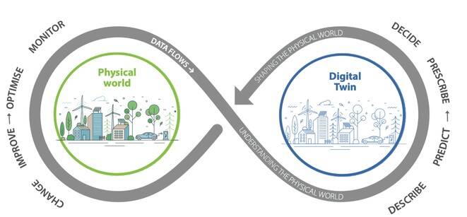
A digital twin allows for bi-directional data exchange. Beyond real-time monitoring of physical systems, data can also flow from the digital model back to the physical systems, providing new input to optimize their performance.
Semantic Web
The Semantic Web structures information in a way that allows it to be automatically processed by machines. By combining structured data with inferencing, it can generate insights that are not explicitly stated in the original data.

Impacts

Technological Advancements
- Creation of a high-fidelity, interactive digital twin mirroring urban topography, infrastructure, hydrological patterns, and human behaviors.
- Integration of a Semantic City Model with metadata for complex queries and comprehensive data analysis.
- Incorporation of a knowledge graph system for flood resilience and simulation models predicting flood scenarios and responses.

Societal Impacts
- Enhanced understanding of urban system dynamics for urban planners, policy-makers, and researchers.
- Increased adoption of digital twin technology and data-driven decision-making.
- More accurate predictive models and efficient flood response strategies, reducing cities’ vulnerability to floods.

Urban Resilience
- Improved planning, development, and management of environmental challenges.
- Quantifiable and specific outcomes in resilience indicators.
- Transformational shifts in urban governance towards data-driven, resilient, and sustainable practices.

Policy and Stakeholder Engagement
- Policy reforms driving improved urban resilience and sustainability practices.
- Enhanced stakeholder engagement, leading to measurable improvements in urban resilience and sustainability indicators.


